NOTES ON THE
MANOR OF THORLEY HALL,
AND THE SUBTERRANEAN PASSAGES
DISCOVERED THERE.AT the office of Mr. Hare, Solicitor, Great Hadham, are four books, in which are entered "Drafts of the Court Rolls examined." The earliest book is endorsed Vol. iii, and dates from 1773 to 1785.
"This is the beginning of Volume the third of Draughts of the Court Rolls kept of and for the Manor of Thorley Hall, in the County of Hertford, and which being likewise carefully examined therewith, are to be properly called also Examined Copies thereof and will be used by one as such (the Lord of the Manor having been always accustomed to keep the Rolls himself)."
General Court Baron of Mathew Raper, Esq., 4th Oct., 1772.
John Usher, of the Inner Temple, London,
General Steward.John Usher in Court of 1777 is described as of Stortford.
In Court of 1777, April 5 :
Proclamation of death of Thos. Adderley, Esq., late of Bp. Stortford.
In Court, April 25, 1777 :
States that late Thos. Adderley was admitted tenant in 1776.
His exor appear at the Court.
John Beecroft, of Paternoster Row, London, Bookseller, and Charles Clapton, of Widford Street, gent. - his will dated 7 Feb., 1774, provd P.C.C. 26 April, 1774 - Mentions his wife Millicent. All for her life. After her death a farm called Haven, part copy, part free, in Stortford and Thorley. Mentions his sister Eliz Hawes - his nephew Francis Hawes, niece Elizabeth Adderley - his sisters, Ann Adderley and Sarah Coates.Wardall Baynes, of Stortford, Coal Merchant, appeared for Geo. Jackson, Esq.
In 1780. John Raper is Lord. John Usher, Steward.
In 1781. John Peters Grant, Esq., a minor (by William Grant, Doctor of Physic, his father) Lord. John Usher, Steward.
1791. John Usher was Steward.
1797. Court of John Peters Grant held at Coach & Horses, Thorley. David Neale, gent., Bp. Stortford, Steward.
In 1802. Robert Howard, Steward.
W. B. Gerish
_________
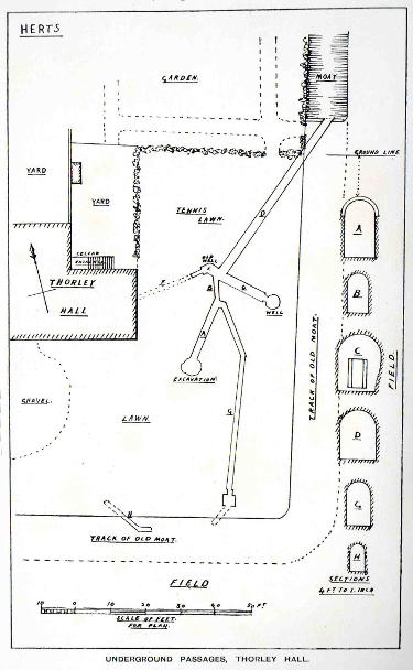
THE SUBTERRANEAN PASSAGES
During the latter part of the year 1903, intimation was conveyed to the Society's Secretary that there was at Thorley Hall a suspected underground passage to Shingle Hall, which the tenant (Mr. W. Jasper) had discovered quite by accident in digging for the purpose of planting a tree. He found that such a way was in existence, and had penetrated it for some considerable distance, but was compelled to desist on account of the air becoming foul ; since when the passing of heavy farm waggons and machinery had caused the crown to collapse, as evidenced by depressions in the ground along the course of the passage. Since that time he has courteously allowed the members of the Society to inspect the site, and has opened up more of this interesting subject. On a visit of the Society to Thorley Hall on October 3rd, 1903, it was found that some further progress had been made in the attempt to elucidate the intention of the builders of these passages, and to determine a reason for their existence. The Society, under the supervision of the Hon. Treasurer, excavated the tennis lawn on the east side of the Hall, with the result that several passages were discovered, all built of red brick of varying thickness, arched over with semicircular arches also in brick, and paved with the same. The first piece to be opened was found to be nearly 20 ft. long, 2 ft. 4 in. wide, and 4 ft. 1 in. high to the crown of the arch, and 3 ft. 4 in. under the ground, its direction being nearly north-east and south-west. At the end of this was a short low tunnel, 6 ft, long, 1 ft. 6 in. wide, and 2 ft. high, which turned at an angle directly north, and across which, at the farther end, was an old piece of timber carrying three courses of brickwork, which was evidently part of the foundations of a building ; and local tradition assigns, and with every show of probability, that part of the outer wall of the old Hall was supported by this beam on this site.
This latter tunnel opened into a large irregular-shaped space, where, it was believed, a well formerly existed, originally about 30 ft. deep, but which at the time was filled with earth and rubbish. From this, in a direct line with the narrow tunnel, was a brick culvert 56 ft. in length, 3 ft. high, and 2 ft. 6 in. wide, that finally, joined in a north-easterly direction the old moat, which at one time surrounded the Manor-house and Churchyard. On the west side of the irregular space before mentioned was a small opening 1 ft. 1 in. wide, and 2 ft. high, which evidently ran towards some part of the old Manor-house, but is now stopped off by earth for all its length, except about 2ft. at its entrance. Likewise, from the same irregular cavity, there ran nearly due east a fine culvert, arched as before described, averaging l0 ft. long, 2 ft. 9 in. wide on the floor, and 3 ft. 2 in. wide at the springing of the arch, and 4 ft. in height. This was apparently unpaved, and at the end was a well 4 ft. 3 in. in diameter (overflowing the floor with water 4 in. deep), having a depth at the present of 28 ft, but it was said to be originally 60 ft. This well was domed over in brick, and had a narrow splayed opening into it, forming an entrance, finished above with a wooden lintel. Returning to the entrance, and passing up the first-named passage, an opening was met with on the right or east side, which was the beginning of another passage. This turned off sharply towards the south-east, and ran in a straight line for about 13 ft., then turned south for upwards of 38ft., at which point there appeared to have been brickwork built to receive either wood or stone, so that it might be stopped off or closed within a square brick pit about 24 in. each way. From this point there were no remains of more brickwork, yet the earth was different, and showed signs of having been moved at some time, but excavations were only made for a further length of 8ft. towards the south-west. This long channel was 3 ft. 1 in. high, and 1 ft. 6 in. wide, and from the general character of the bricks, this, and the small 6 ft. opening, and the 56 ft. length to the moat, were certainly the oldest part of the structure ; but the first-named passage, and the irregular cavity, and the way to the well, appeared to have been added in much later times, perhaps within the last 100 years, or early in the nineteenth century. The mortar was exceedingly tough and good (as almost all mortar becomes when in a constantly damp situation), with an abundance of lime in its composition, and the bricks were of the common thickness, viz. 2 3/8 in., whereas in the older portion they were but 2 1/8 in. There was also found a very small brick culvert 30 ft. to the westward of the brick pit ; it was only 2 ft. high and 1 ft. 1 in. wide inside, its length being 18 ft. or thereabouts. It was within 1 ft. of the surface, and its direction and fall appeared to be north-west and south-east. With this exception, the fall of all the other passages or culverts was very slight, and was from south to north. Notwithstanding all this excavation, there was found nothing whatever that would give any colour to the tradition of the existence of underground passages from Thorley Hall to Shingle Hall. Salmon, who wrote in 1728, referred to a place called Clements, in Thorley, "which had brick drains for a great way." By this name the present Thorley Hall was then known, and the discoveries now mentioned show that he was perfectly correct in his description, for these passages are only believed to be watercourses formed to carry the water from one part of the site to the other. It is said that the old house of Clements had three wings joined together at one end by a long main building, and that this part where these culverts are found was an old courtyard, and the present building was one of the original wings. It is impossible at this date to account for the existence of two wells in such close proximity ; but there is little doubt they were constructed for some definite purpose, and joined to the old culvert as shown by the excavations, and that in very wet weather the overflow from them runs into the old moat to the north. There is also every probability of this old culvert being in early times an open watercourse or ditch, leading from the moat on the south to the moat at the north-east. But when more settled times came, the arms of the moat on the east and south-east were filled up, and probably an extension of the courtyard made, and the watercourses being a nuisance, the culverts became essential, and were built. There is no question but that the moat encircled the whole of this manor-house and churchyard, for on examination of the ground (though it is now irregular as to heights, etc.) it is clearly traceable from the south end of these culverts (the smaller of which ran into, and the larger out of it). The moat was probably 12 to 14 feet or more, broad, and ran along the south fence of the present garden, and by the south side of the barn in the stackyard (where not long since, a thrashing engine sank in at least three feet), up to the new portion of the churchyard (which was added some nine to ten years since, and where it is said the soil is always waterlogged) to the west side of the churchyard, where it turned to the north to the farther side, and then to the east to the large pond (which is only a part of the enlarged moat), and thence across the road (then a ford or a culvert which formed the entrance to the Hall) to the back of the large barn (which was most likely a tithe barn at that time), and so passing along by the back of this barn to the head of the moat where it is now clearly defined against the road, and which runs down the north side of the garden for 200 feet to its farthest corner, and then turns southward again another 200 feet ; the total enclosure being about four acres. There are two ponds just west of the church, but these are evidently modern, merely excavations for gravel ; nevertheless, as they hold water it shows that from this part in former times the moat was kept supplied, even as the large pond on the north of the church is at the present day. Seeing that the moat was filled, or stopped off, at the eastern side for some distance, it appears very likely that these culverts were formed to connect its two ends, and prevent the danger of overflow.
The Ordnance level of Thorley Hall is 286 ft. 8 in. above high-water mark at Liverpool, and of Shingle Hall, distant 1 mile 220 yards to the south-west, 281 feet, but between these two places there is a large brook which comes down from Brook Farm, and to which the ground falls. Also direct south from Thorley Hall is Henley Herne spring, at a distance of 960 yards, where the level is but 220 feet ; the figures southward being 286 ft. 8 in., 278 feet, 274 feet, 258 ft. 7 in., with 233 feet at the boundary of Thorley parish, 224 feet at Sawbridgeworth parish footpath, 223 feet in Long Mead near the footpath, and 220 feet at the brook. Again, at Shingle Hall, which is 281 feet, it is 278 feet at the east side, 275 feet at Trims Green, and falls towards the south, whilst to the north of Thorley Hall the ground is high. As to the moat in Marthams, Mathams, or Madams Wood being connected, it is impossible, as it lies at the 300 feet level, and would be kept supplied by the wood itself and higher ground, and overflow also into the brook. Salmon suggests that Mathams Wood was part of the park which Henry VI granted to Mr. Leventhorpe in 1422-1461 to enclose, and he then goes on to speak of the pond in the wood as follows : - '' In the wood is a very large pond, of an oblong figure, regularly made, which if it were not for the height of the bank all round it, would in our age obtain the name of canal."
It is surprising to note the number and size of the ditches in and about the neighbourhood, many of which form small ravines. The one at the north-east corner of the Thorley moat is an instance, and were this filled up for a few yards, the moat would once more fill with water, and perhaps become a nuisance and source of danger. It will therefore be understood that the tradition of an underground passage from Thorley Hall to Shingle Hall could have no foundation in fact ; there is nothing at the first-named place to warrant any such, or if there were, it would pass down a declivity parallel from 286 to 220 feet, and somewhat underground, and then uphill again to 281 feet. It is very doubtful whether the builders of that time could make such a passage watertight ; the lowest portion for a long distance would be so full of water that nothing could pass along it. A parallel case was cited in my paper on the supposed underground passage from the Rye House Castle to Nether Hall in Essex (E.H.A.S. Trans., Vol. II, p. 44), where such a passage would have to pass several large ditches, and under the River Stort, although the surface would be much nearer level. On a casual inspection of the outside, the Hall does not show any signs of antiquity, save on the west side, where the timbers and plaster front are visible, the other portions of the house having been subsequently faced with brick. But that there is some probability of the present building being part of the old house is witnessed by the fact that in the room in the roof over the kitchen there are the two ends of a large oak beam, 12 inches square, the centre of which has been cut away, and the ends supported by immense oak braces, well tenoned and pinned together, and on which stand the queen posts, 10 1/2 inches by 10 inches, having ornamental moulded bases 7 inches high, and apparently of Early English work. These posts support other large timbers, to which they are braced with straight braces 7 inches square, and curved braces 7 by 6 inches, to an apparent collar beam in the roof, which no doubt carries a king post, also braced each way to timbers which either support the rafters or to the rafters themselves, as also appears in the main roof of the building, where the rafters are all of solid oak 7 by 5 inches, and as good to-day as when first placed in position perhaps three or four centuries ago, and calculated to last quite as long again.
The cellars do not appear to be extensive, or to exist under the whole area of the house, as the present kitchen floor is a tiled one. They are somewhat damp, and have an opening on the north side which is modern, being only about fifteen to sixteen years old. The difference of the brickwork, inside and out, is also seen in that opening, where it is irregularly bonded, four courses of the new work occupying the same thickness as five of the old. The walls within are partly plain and partly plastered ; the differences point to where partitions have been formerly fixed, and shelves and bins in the thickness of the old chimney foundation. There is one width of plaster on the south side of the outermost cellar which may, perhaps, cover an original doorway leading somewhere, but no knowledge of any passage from it is in existence.
The dampness of the site arises from the fact of the subsoil lining a chalk marl or marly clay of very stiff character, covered by a thin layer of loam, and it retains water to a very considerable extent. The tennis lawn has been raised some two feet on the east side and lowered slightly towards the west to obtain a fair level. The culverts may be compared with those that occur at Bayley Hall, Hertford, more especially as regards the brickwork, but not as to their use ; for while those at Thorley were unquestionably aqueducts or culverts for water, those in Hertford were true secret passages, which conducted from one definite point in the house to an obscure opening in the courtyard, and from the main passage by a branch at nearly a right angle with an ancient groined cellar of the next premises, which were formerly the King's Arms Inn. These are complete in themselves with only the ends blocked, whereas those at Thorley have been broken into and filled up for considerable lengths with earth, and entirely lost (as to their destination) at the south ends. Tradition also tells of two avenues which formerly led from the Hall towards Thorley House and Spelbrook. Of these no traces remain. One other feature of this district is the very large number of footpaths through the fields. On this farm it is said that there are but two fields left that have none in or about them.
R. T. ANDREWS.
Philip Hargrave
April 2016